
Introduction
Red rock towers rising from rust-colored earth. Trails that wind through canyons so quiet you can hear your own footsteps. Sedona has a way of looking overwhelming in photos — all drama and altitude — but first-time hikers consistently find it more welcoming than expected.
That reputation for being "too intense" is largely undeserved. Most of Sedona's famous scenery sits within easy reach of short, well-marked trails that don't demand technical skill or serious fitness. What they do demand is a little preparation: understanding the elevation, respecting the desert heat, and knowing where to leave your car — which is less obvious than it sounds in a town built around trail access.
All of that is covered here — 6 beginner-friendly trails worth your time, what to pack and prep before you set out, and a few practical pointers for navigating the town itself.
Key Takeaways
- Sedona sits at roughly 4,350 feet — pace yourself and drink more water than usual
- A Red Rock Pass ($5 daily / $15 weekly) or America the Beautiful Pass is required for parking at most trailheads
- These 6 trails range from 0.8 to 4.1 miles, with manageable elevation gain — no prior hiking experience needed
- Arrive before 8am at popular trailheads, or use the free Sedona Shuttle (runs Thursday–Sunday)
- Best seasons: spring (March–May) and fall (September–November) — summer highs regularly reach 96°F
Before You Hit the Trail: What Every Beginner Should Know
The Red Rock Pass
Most trailheads in Sedona fall within Coconino National Forest fee sites, and parking without a pass will earn you a fine. According to the Coconino National Forest Red Rock Recreation Guide (July 2024), passes are priced at:
- Daily: $5
- Weekly: $15
- Annual: $20
You can purchase passes at trailhead kiosks, the Red Rock Ranger District Visitor Center, local retailers, and Recreation.gov. If you already hold an America the Beautiful National Parks Pass (or any Federal Recreation Lands Pass), it's accepted as a substitute — no separate purchase needed.
Elevation and Desert Conditions
At 4,350 feet, Sedona sits higher than most East Coast mountain resorts. That elevation, combined with intense sun and low humidity, tires people out faster than they expect — especially visitors arriving from sea level. Heat is the bigger concern in summer: NOAA climate data for Sedona shows normal maximum temperatures of 96.9°F in July and 94.1°F in June.
Two rules that matter most:
- Start early. Aim to finish before 9am in summer — early starts mean cooler temps and emptier trailheads year-round.
- Drink consistently. Plan on half to one quart per hour, more in the heat — and drink before you feel thirsty.
What to Pack
A half-day hike here doesn't need a heavy pack — but these four things are non-negotiable:
- Footwear: Trail runners or hiking boots with grip. Not sandals.
- Water: At least 2 liters per person
- Sun protection: Sunscreen, hat, and UV-protective clothing
- Navigation: Download AllTrails offline before you leave cell range — several of these trails have unmarked turns

6 Easy Hikes in Sedona for Beginners
These trails were selected because they deliver Sedona's most iconic scenery with manageable distances, low-to-moderate elevation gain, and paths that are straightforward to follow without a guide.
Bell Rock Trail
Distance: 0.8 miles out-and-back (Bell Rock Trail) | Elevation gain: Minimal on approach | Difficulty: Moderate | Pathway option: Forest Service Bell Rock Pathway No. 96 extends to 3.5 miles one way with 185 ft gain (rated easy/family-friendly)
Bell Rock is one of Sedona's most recognizable formations : a broad, dome-shaped mesa you can see from the highway. The approach trail is mostly flat and well-worn, making it low-pressure for first-timers. What makes it special is that there's no required destination: you can walk to the base, scramble partway up the rock face, or simply circle it. The choice is yours.
Bell Rock is also one of Sedona's four best-known energy vortex sites, drawing wellness-curious visitors alongside hikers. Whether or not you subscribe to vortex energy, the formation is worth the stop.
Practical tip: Parking fills fast, especially on weekends. Arrive before 8am, or use the Bell Rock Pathway for a longer but still easy experience ; the trailheads along SR 179 give you multiple access points.
Airport Mesa Loop Trail
Distance: 3.3-mile loop (426 ft gain) or 1.4-mile Airport View Trail (216 ft gain) | Difficulty: Moderate | Trailhead: Near Sedona Airport
Airport Mesa delivers the kind of panoramic payoff that usually requires a much harder hike. The loop circles above Sedona's red rock valley, offering 360-degree views without demanding steep or technical terrain. Sunset is particularly rewarding here : the light turns the surrounding formations deep amber and red.
Like Bell Rock, Airport Mesa is a recognized vortex site. For beginners who want a shorter option, the Airport View Trail at 1.4 miles is a more manageable introduction with nearly the same views.
Practical tip: The trailhead lot is small and fills quickly. The Sedona Airport Scenic Overlook offers nearby parking ; regular passenger vehicles pay $3 for the day, which covers the full visit. From there, it's a short walk to the trailhead.
Fay Canyon Trail
Distance: Approximately 2.1 miles out-and-back | Difficulty: Moderate | Terrain: Sandy, mostly flat canyon floor
Fay Canyon is quieter than most Sedona trails : the kind of walk where you're surrounded by towering red walls on both sides and the only sounds are wind and footsteps. The main trail is straightforward walking through a canyon, and the Forest Service maintains a dedicated trail page (No. 53) confirming the route.
There's also a spur trail branching uphill toward a natural stone arch (worth the detour if you notice the side trail opening up as you walk deeper into the canyon. It adds only a few minutes to the total time.)
Before you go: The arch spur can be easy to miss if you're not watching for it. Download the AllTrails route before you go and glance at the map as you walk ; the branch appears roughly mid-trail. Parking at the Fay Canyon Trailhead tends to be more manageable than at Sedona's most-visited spots.
Birthing Cave Trail
Distance: 2.0 miles out-and-back | Elevation gain: 232 ft | Difficulty: Moderate | Rating: 4.7/5 from 14,628 AllTrails reviews
Birthing Cave earns its 4.7-star rating with a finish most trails can't match. The route stays nearly flat until the final approach, where a short scramble leads into a large curved cave carved into the cliffside. From inside, the opening frames a wide view of the red rock valley — a genuinely striking payoff for a 2-mile round trip.
One thing worth noting: AllTrails lists this as an unofficial social trail not maintained by the Forest Service, and cell service can be absent once you're past the trailhead. Download the route offline before you leave.
Practical tip: The turn-off to the cave is unmarked on the ground. Use AllTrails GPS to catch the split ; it appears at roughly the 0.6-mile mark. Go early to avoid crowds inside the cave; it's a tight space that feels very different when it's full.
Baldwin Trail to Red Rock Crossing
Distance: 2.7-mile loop | Elevation gain: 285 ft | Difficulty: Moderate | Trailhead: Off Verde Valley School Road
This trail leads to one of Sedona's most striking views: Cathedral Rock reflected in the surface of Oak Creek at Red Rock Crossing. The creek itself is a destination : shaded, photogenic, and easy to spend time at whether you wade, picnic, or just sit with the view.
The full Baldwin Loop mixes terrain nicely, moving through forest, creek, and desert sections that give beginners a varied experience without a serious climb. According to Visit Sedona's Red Rock Crossing page, golden hour before sunset produces the best reflections of Cathedral Rock in the water.
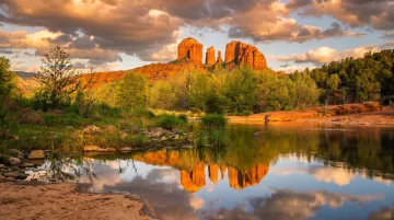
Worth knowing: The final stretch to the trailhead turns to gravel road, but it's manageable for most passenger vehicles. Afternoon light is best for photography at the creek.
Devil's Bridge Trail
Distance: 4.1 miles out-and-back via Mescal Trailhead (recommended for standard vehicles) | 1.6 miles round trip from the high-clearance Forest Service trailhead | Elevation gain: ~521 ft via Mescal | Difficulty: Moderate
Devil's Bridge is Sedona's most popular trail, and according to the Forest Service trail page, it leads to the largest natural sandstone arch in the Sedona area. That's the draw: a wide sandstone span you can walk across, with open air on both sides and red rock canyon below.
The majority of the route via Mescal Trailhead follows an old 4x4 road: flat, wide, and easy walking. The challenge arrives in the final section, a rocky scramble up to the bridge itself. For beginners who take their time and wear shoes with grip, it's manageable. The arch feels wider and more stable underfoot than photos suggest.
Practical tip: This trail is extremely popular. The parking lot fills before 7am on busy days. Come very early, or take the Mescal Trailhead approach via Long Canyon Road (the longer but more scenic alternative for standard vehicles). Expect a wait to take a photo on the bridge during peak hours.
Tips for Getting the Most Out of Your Sedona Hiking Trip
Timing and Crowds
The single most effective thing beginners can do is arrive early. For the most popular trails — Devil's Bridge, Bell Rock, Airport Mesa — aim for before 7am on weekdays is ideal. Weekend afternoons can feel genuinely overwhelming at parking lots and on the trail itself.
The Sedona Shuttle Trailhead Routes run year-round, Thursday through Sunday, with no reservations required. Routes cover Dry Creek Vista, Soldier Pass, Cathedral Rock, Little Horse, and Mescal — covering access points for several trails on this list. It's a practical option that removes parking stress entirely.
Leave No Trace
Sedona's trails are heavily visited and the landscape is more fragile than it looks. A few habits make a real difference:
- Stay on marked trails — off-trail walking damages desert soil crust
- Pack out everything, including food scraps
- Yield to uphill hikers on narrow sections
- Keep dogs leashed
- Leave the rocks as you find them — no cairn-building, carving, or paint
Staying Close to the Trails
Early morning hikes are dramatically easier when you're already close to the trailheads. Sun Haven Collection's three Sedona properties — Desert Solace at Bristlecone, Mesa Vista on Cline, and Dry Creek Sunstone Home — are each positioned in West Sedona or along the trail corridors covered in this guide.
The Dry Creek Sunstone Home sits along Dry Creek Road, directly adjacent to the trail systems connecting to Devil's Bridge via the Mescal approach. Mesa Vista on Cline includes an outdoor shower on the patio, genuinely useful after a dusty canyon walk, plus an indoor gym for post-hike recovery. All three properties include concierge support with trail recommendations and planning assistance before and during your stay.

For guests interested in a more structured hiking experience, Sun Haven's Adventure & Exploration package includes custom itinerary planning, guided hike options, and on-call concierge support throughout the stay.
Conclusion
Sedona's trail network genuinely rewards beginners. The scenery is extraordinary, the paths are mostly well-marked, and the distances are short enough that most healthy adults can complete these hikes without prior experience — provided they respect the elevation and heat.
The harder part is often the logistics: parking, timing, knowing what to bring. Getting those details right before you arrive changes the whole experience.
Sun Haven Collection's Sedona properties are designed around exactly this kind of stay — quiet mornings, trailhead access within a short drive, and outdoor living spaces that make it easy to decompress after a morning on the trail. Desert Solace at Bristlecone, Mesa Vista on Cline, and Dry Creek Sunstone Home each sit close to the routes covered in this guide.
Check availability to explore properties and start planning your Sedona stay.
Frequently Asked Questions
Are Sedona hikes good for beginners?
Yes — Sedona has a wide range of beginner-friendly trails that are short, well-marked, and relatively flat with stunning views. The main things to prepare for are the desert heat and the elevation of around 4,350 feet, both of which tire people out faster than expected.
Can a beginner hike Cathedral Rock?
Cathedral Rock is rated hard on AllTrails, with significant elevation gain in a short distance and steep rock scrambling involved. Fit beginners with good shoes can complete it if they take their time, but it's not the best starting trail for first-time visitors to Sedona.
What is the most popular trail in Sedona?
Devil's Bridge is Sedona's most popular and most photographed trail, known for the large natural sandstone arch that hikers can walk across. Its popularity means full parking lots, especially on weekends and during spring and fall peak season — arrive before 8am or use the shuttle from the Dry Creek Trailhead to avoid the wait.
What is the easiest vortex to walk to in Sedona?
Airport Mesa is one of the easiest vortex sites to access, with a short trail option and a paved scenic overlook nearby that can be reached by car. Bell Rock is another easy option reachable on foot with minimal elevation gain from the SR 179 trailheads.
Do you need a permit to hike in Sedona?
No hiking permit is required, but a Red Rock Pass is needed for parking at most Coconino National Forest trailheads — currently $5 daily or $15 weekly. The America the Beautiful National Parks Pass is accepted as a substitute at fee sites.
What is the best time of year to hike in Sedona as a beginner?
Spring (March through May) and fall (September through November) offer the most comfortable conditions, with mild temperatures and lighter trail traffic. Summer highs frequently exceed 96°F, so if you're visiting then, plan to be back at your car by 9am.