
The trail network here covers every experience level. A family with young children can loop around Bell Rock in two hours. A solo hiker can spend a full morning on Cathedral Rock and feel genuinely tested. A group coming for wellness and scenery will find something different on every day of a week-long stay.
This guide covers seven essential trails — what each one looks like on the ground, accurate trail stats, and the practical logistics (passes, parking, shuttle access, timing) that separate a smooth Sedona hiking trip from a frustrating one.
Key Takeaways
- Seven trails to know: Devil's Bridge, Cathedral Rock, Boynton Canyon (with Subway Cave), Soldier's Pass, Bell Rock & Courthouse Butte Loop, West Fork, and Doe Mountain
- Red Rock Pass required ($5/day) at most trailheads — the free Sedona Shuttle (Thu–Sun, 7am–5:30pm) covers Cathedral Rock, Soldier's Pass, and Devil's Bridge access
- Difficulty ranges widely: West Fork is a flat, shaded walk; Cathedral Rock is a hands-and-feet scramble — know your group before you go
- Best seasons are spring (March–May) and fall (September–November); summer hiking means starting before 7am
- Download AllTrails offline before you go — cell service drops at several trailheads, particularly in Oak Creek Canyon
Why Sedona Is One of America's Best Places to Hike
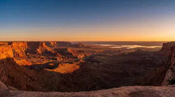
Sedona sits at roughly 4,300–4,500 feet in northern Arizona, surrounded by red Permian sandstone formations shaped over millions of years. The landscape gives every trail a visual quality that's difficult to find elsewhere — even moderate hikes feel cinematic.
Beyond scenery, Sedona draws visitors seeking what Visit Sedona describes as energy, healing, and self-exploration. Four major vortex sites anchor this side of the appeal:
- Airport Mesa
- Cathedral Rock
- Bell Rock
- Boynton Canyon
Trails near these sites attract wellness-minded travelers looking for something more than physical exercise.
That draw adds up. A 2024 analysis cited by Sedona Red Rock News put annual visits at approximately 2.9 million in 2023. At that volume, trail selection and timing matter — arriving at Devil's Bridge at 6:30am versus 9am is the difference between solitude and a 30-minute queue at the arch.
The Best Hiking Trails in Sedona
These seven trails represent the strongest combination of scenery, variety, and accessibility across Sedona's trail network — covering different fitness levels, group types, and goals.
Devil's Bridge
Stats: 1.6 miles round trip from the Devil's Bridge trailhead (longer via Mescal Trailhead approach) | Moderate | 371 ft elevation gain | No shade | Best at sunrise
Devil's Bridge is the largest natural sandstone arch in the Sedona area. What sets it apart from a viewpoint-only destination: hikers can walk across the top of the arch itself, standing suspended above the canyon floor for the photo that's made Devil's Bridge one of the most searched trail images in the Southwest.
The crowd reality is significant. The arch viewing area becomes congested by mid-morning, and waits to photograph on the arch can stretch well past 30 minutes. Arriving before 7am is the clearest way to avoid it.
A few logistics worth knowing:
- The main trailhead lot fills fast; Mescal Trailhead offers a more scenic approach with more realistic parking
- FR 152 access road is rough and requires a high-clearance vehicle; not recommended in wet weather
- The free Sedona Shuttle (Route 11) serves Dry Creek Vista and Mescal from the West SR 89A Park and Ride — a strong alternative on Thursday–Sunday
- Verify Red Rock Pass requirements at Mescal Trailhead before visiting, as requirements can change

Cathedral Rock
Stats: 1.1 miles round trip | Strenuous | 669 ft elevation gain | No shade | Best at sunrise or sunset
Cathedral Rock is the trail that earns the most consistent praise from returning Sedona hikers. It's short, but the final section involves genuine scrambling : hands on rock, careful foot placement, no railing. The payoff at the top is a 360-degree view across the valley, with Courthouse Butte, Bell Rock, and the Chapel of the Holy Cross visible in the distance.
This is also one of Sedona's four major vortex sites, which draws a different category of visitor : meditation groups, solo sunrise seekers, couples marking something meaningful.
Practical notes:
- Parking at the trailhead is very limited; the free Shuttle Route 15 serves Cathedral Rock on operating days, and the trailhead lot closes during shuttle hours — plan accordingly
- Height-averse hikers don't need to reach the summit for strong views; the trail rewards at several points below the top
- Best sunrise access means arriving at the trailhead before 6am in peak season
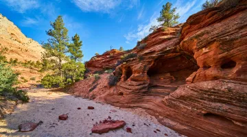
Boynton Canyon Trail (+ Subway Cave)
Stats: 6.6 miles round trip (full canyon) | 4.8 miles to Subway Cave | Moderate | 931 ft elevation gain | Partial shade | Best in the morning
Boynton Canyon runs through one of Sedona's most consistent stretches of red rock scenery. The canyon walls follow you from the trailhead to the far end without much interruption, and the route passes through one of the four vortex sites, with the energy point located near the trailhead area.
The Subway Cave is the standout feature for most visitors: a wide natural arch whose curved red walls frame a cathedral-like interior. It sits on a side route within the first portion of the trail — check current AllTrails or USFS maps for the exact junction before heading out.
A few things to flag:
- Red Rock Pass or America the Beautiful Pass required for trailhead parking
- Partial canyon shade makes this relatively more manageable in warmer months than fully exposed routes
- Wildlife is present throughout the area; javelina and coyotes are commonly seen across Sedona's trail environments
Soldier's Pass Trail
Stats: 4–4.8 miles round trip | Moderate | 641–836 ft elevation gain (depending on route) | Partial shade | Trailhead opens at 8am
Soldier's Pass packs more distinct points of interest into a single hike than almost anything else on this list. The Seven Sacred Pools are sandstone basins carved by a seasonal stream, most impressive after recent rainfall. Devil's Kitchen Sinkhole is a large active depression formed when an underground cavern collapsed.
Caves appear further along the trail as the terrain opens up — making this one of the few routes in Sedona that changes character as you move through it.
The trailhead has only 14 parking spots and fills immediately at 8am opening. Getting there first is nearly impossible on a weekend. Plan around the Sedona Shuttle (Route 14 from Posse Grounds Park and Ride) — it's the most reliable access option on operating days.
Jeep tours share part of this route, so expect occasional vehicle traffic on the lower sections.
Bell Rock & Courthouse Butte Loop
Stats: 3.7–3.8 miles loop | Moderate | ~341 ft elevation gain | Little shade | Outstanding at sunset
This is the most accessible trail on this list for families, less experienced hikers, or anyone wanting iconic Sedona scenery without a significant physical commitment. The Courthouse Butte loop circles two of the region's most recognizable formations at a comfortable pace, with views that hold throughout the entire route rather than concentrating at a single summit.
Adding the Bell Rock scramble (a short rocky climb onto the rock itself) is recommended for anyone with comfortable footing. Bell Rock is one of Sedona's four vortex sites and a well-known spot for sunset meditation.
Access notes:
- Courthouse Vista (Bell Rock North) is the recommended parking area
- Bell Rock Vista at the south end is an alternative starting point
- First-time Sedona visitors consistently rank this loop as the most rewarding introduction to the area: the loop format means no backtracking, and the views start immediately off the trailhead
West Fork Trail
Stats: 6.5 miles round trip | Moderate | Minimal elevation gain over first 3 miles | 13 creek crossings | Heavily shaded | Best in summer or fall
West Fork runs through Oak Creek Canyon, 9.5 miles north of Sedona, and it's the only trail on this list that offers genuine shade and riparian scenery. Thirteen creek crossings break up the walk ; waterproof footwear or dry bags for shoes are worth considering.
This is the go-to summer recommendation. When every other Sedona trail is fully exposed by 9am, West Fork stays cool under a tree canopy for most of its length.
Important fee note: The Call of the Canyon day-use fee is currently $15 daily (not $12 as sometimes cited). The standard Red Rock Pass and America the Beautiful Pass are not accepted here ; only the Grand Annual Red Rock Pass or the daily gate fee. Verify current fees at the USFS West Fork Trail page before visiting.
Doe Mountain
Stats: 0.7 miles to mesa top (1.6 miles including the mesa rim loop) | Moderate | ~485–542 ft elevation gain | No shade | Outstanding at sunrise
Doe Mountain is underrated. The approach switchbacks steeply to the top of a wide, flat mesa (a geological formation created by erosion-resistant cap rock) and the summit feels different from every other trail in Sedona. There's actual space up there. Room to wander, find a quiet edge, and sit with the view without crowding anyone else out.
At sunrise, hot air balloon flights frequently ascend over the valley, visible from the rim. The hike is short enough to complete before 8am, which makes it an easy first-day or last-morning trail without sacrificing the reward.
Best suited for: groups, families with older children, or anyone who wants high-reward panoramic views without the rock scrambling of Cathedral Rock or Devil's Bridge.
Before You Go: Practical Hiking Tips for Sedona
Red Rock Pass and Parking
Most trailheads within Coconino National Forest require a Red Rock Pass ($5/day, $15/week, $20/annual) or a qualifying America the Beautiful interagency pass displayed in the vehicle. Passes are available at automated kiosks at major trailheads.
The free Sedona Shuttle (Thursday–Sunday, 7am–5:30pm) serves Cathedral Rock, Soldier's Pass, Little Horse, Dry Creek Vista (for Devil's Bridge access), and Mescal. On operating days, some popular trailhead lots close — build shuttle access into your plan rather than treating it as a backup.
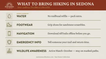
What to Bring
- Water: No refill stations at trailheads; pack more than you expect to need
- Footwear: Shoes with real grip — Sedona's sandstone is uneven and the exposed rock sections on Cathedral Rock and Devil's Bridge require traction
- Navigation: Download AllTrails with offline maps before leaving cell range; service is unreliable in Oak Creek Canyon and at several western trailheads
- Emergency info: Tell someone your planned trail and expected return time
- Wildlife: Rattlesnakes are most active March through October according to Arizona Game and Fish. Javelina and coyotes are commonly seen across Sedona's trails — stay on marked paths, watch where you step, and avoid reaching into rock crevices
Leave No Trace
Sedona's trail network handles close to 3 million annual visits, and trail erosion is a serious, ongoing problem. Staying on marked paths is what keeps the landscape intact for the next group — not just good etiquette. Pack out everything, don't remove rocks or natural objects, and give other hikers space on narrow sections.
A little preparation goes a long way out here. The trails reward it.
Best Time of Year to Hike in Sedona
| Season | Avg High | Avg Low | Notes |
|---|---|---|---|
| Spring (Mar–May) | 67–84°F | 41–55°F | Best overall window; cool mornings, warm afternoons, wildflowers |
| Summer (Jun–Aug) | 94–97°F | 64–71°F | Viable only with pre-7am starts; monsoon afternoon storms add risk |
| Fall (Sep–Nov) | 66–89°F | 41–64°F | Best overall window; cooler after peak heat, fall color on West Fork |
| Winter (Dec–Feb) | 57–61°F | 34–37°F | Quieter crowds, comfortable on exposed trails; occasional snow |
REI's Sedona hiking guide identifies spring and fall as the ideal seasons, with specific warnings about intense sun and afternoon thunderstorms during summer monsoon months.
What that guide underplays is winter. Crowds thin considerably, temperatures make longer exposed climbs comfortable, and the red rocks look genuinely different after a light dusting of snow. For anyone prioritizing trail quiet over peak conditions, January and February deliver a version of Sedona that most visitors never encounter.
Conclusion
Sedona rewards hikers who show up prepared — early starts, the right pass, an offline map, and a trail matched to the day. Do those things and the landscape tends to take care of the rest. Even a single morning on the red rocks leaves an impression that most destinations take a week to build.
The other half of a Sedona hiking trip is what you return to at the end of the day. Sun Haven Collection's three Sedona properties are designed for exactly that kind of recovery:
- Mesa Vista on Cline — private pool, hot tub, and a full indoor gym for post-trail recovery
- Dry Creek Sunstone Home — indoor sauna, positioned along Dry Creek Road near the western trailheads
- Desert Solace at Bristlecone — 360-degree red rock views, 8 bedrooms, and space for groups up to 16
All three include concierge support with trail recommendations and local planning built in.
Explore Sun Haven's Sedona properties and find a base that matches the kind of trip you're planning.
Frequently Asked Questions
What is the number one hike in Sedona?
Devil's Bridge is widely considered the most popular trail, drawing visitors for its iconic sandstone arch and dramatic photography. Cathedral Rock is often cited as the most rewarding for views, particularly at sunrise or sunset from the summit scramble.
Which is better, Cathedral Rock or Devil's Bridge?
Cathedral Rock is shorter, steeper, and delivers broader panoramic views. Devil's Bridge is a longer, more gradual approach where the payoff is walking across the arch itself. Choose Cathedral Rock for scenery; choose Devil's Bridge for a distinctive, approachable moderate hike.
Are rattlesnakes common in Sedona?
Rattlesnakes are present and most active March through October, though encounters are uncommon. Stay on marked trails, watch your step around rocks and brush, and you're unlikely to have any issues.
What is the Secret 7 in Sedona?
The Seven Sacred Pools are a series of naturally carved sandstone basins along Soldier's Pass Trail, filled by a seasonal stream. They're most visually impressive after recent rainfall and are accessible as part of the standard Soldier's Pass hike.
Do I need a Red Rock Pass to hike in Sedona?
A Red Rock Pass is required for parking at most Coconino National Forest trailheads — not for hiking itself. Passes cost $5/day and are available at trailhead kiosks. West Fork Trail (Call of the Canyon) charges a separate $15 daily fee and does not accept standard Red Rock or America the Beautiful passes.
What is the best time of year to visit Sedona for hiking?
Spring (March–May) and fall (September–November) are the best windows — comfortable temperatures and manageable crowds. Winter is quieter with mild daytime conditions. Summer is workable if you start before 7am and stick to shaded routes like West Fork.